|
MAP LITERACY
WHAT IS GEO-INFORMATICS
One of the basic requirements for the area development planning is reliable valid and complete database relating to the space. Geo-informatics has emerged as an initiative within the earth sciences division to address the growing recognition that the earth functions as a complete system. Currently the chaotic distribution of the available data sets, lack of documentations about them and lack of easy to use access tools, computer modeling and analysis codes are major obstacles for the scientists and educators. The database that is the basic requirement for the planning is now non-existent or not useful for planning exercises. Geo-informatics is extremely useful in this type of plan preparation, preparing resource and activity schedules as per the organization structures, resource planning and more importantly tracking the progress and complaints. Thus geo-informatics can be thought of as a field in which geo scientists, social scientists and computer scientists are working together to provide the means to address a variety of complex scientific questions using advanced information, technologies and integrated analysis.
MAP LITERACY PROGRAMME IN WEST BENGAL
With a view to enabling people, communities and institutions of local self governance with requisite database and S&T tools for informed participation in local self-governance, NRDMS division intends to create awareness among the school children about utility of maps and Geo-informatics. Thus the project launched taking one representative state from three regions Northern, Eastern and Southern. West Bengal represents the eastern region. West Bengal is a very unique state in India. Its extension from the Himalayas to the north to the bay of Bengal to the south, higher aridity in the western “Rarh” to excess moisture in the eastern part give a distinctive heterogeneity in its physical set up as well as socio-economic environment. Various social groups based on ethnicity, economic status have created their own social areas. There are urban and rural specificities and there are areas enjoying better amenities and some other unprivileged areas. While implementing the programme we expected that the socioeconomic variety of the participating students and the geographical control over the location of schools would have deep impact on the generation of awareness among the target students. The programme revealed a different picture. After successful completion of the project a unique character of homogeneity in the perception level has been emerged across different ethnic groups of various economic strata. This may reflect some kind of homogeneity in cultural and educational system of the state. To put it succinctly, in the diversified environmental set up selection of area for the implementation of such project in four districts namely Jalpaiguri, Purulia, Bankura and Paschim Medinipur do not connote real sample. But for organizational purpose these were selected as all the four districts have NRDMS centres. Three of the western Bengal districts characterize high concentration of tribal population, the proportion of which is not at all reflected in the student community. But the number of scheduled caste student is very high (42%) in Jalpaiguri district. Though it was decided to take only the rural school children we have taken five urban schools to make some comparison between urban and rural sectors. Bankura and Purulia are known to be backward districts while Paschim Medinipur has long heritage of advanced educational development and Jalpaiguri is also coming up. Our experiences while conducting the programme is unique in character. Regarding the interest shown by the students there is hardly any difference between the districts irrespective of the ethnic and economic status of the students. Enormous differences lie in the way of expression and behavioural nature of the students belonging to the backward classes mainly in remote parts of Purulia and Bankura. Less exposure towards modern scientific tools make them bit hesitant while handling geo-informatic tool like GPS. They are shy in indoor activities as well as outdoor work. But quality of the work is no less than that of urban or otherwise privileged students. As a part of study we have made a brief appraisal of the socio-economic status of the participants to understand the interrelationship between ethnicity-economic condition and the awareness level, interest level and perception of students. Attempts have been made to derive quantitative results. Special emphasis has been made to assess the impact of the programme. The analysis clearly reveals that there is no quality difference between the group according to their caste, clan, creed or economic status. But there is difference between the districts. While Jalpaiguri and Paschim Medinipur show higher awareness indices, Bankura and Purulia are lagging behind. There is marked differences in the improvement of the quality of the participating students. While the programme has become successful in elevating knowledge base of the students of backward area, its success is very much exemplified in the upward curve of innovativeness and decision making quality of the already privileged student. This programme has generated tremendous enthusiasm among the children. But it would fulfill its goal only when students of all the schools receive the exposure of this kind of exercises with maps and other geo-informatics and scientific tools. Not only will that it be meaningful if the understanding sustains to exert some impact on the local problem solving through self governance. This can only be done through inclusion of this subject in the school curriculum.
RESOURCE BOOK ON MAP LITERACY
A new book on map literacy in schools, containing methodologies, curriculum and techniques of evaluation is under process. The book in e-book form will be available in pdf format. Price will be approximately Rs. 300.00 ( USD 15.00)per copy. ISML TYPE="counter" OPTION=graphic_7seg
MAP LITERACY TOOL KIT
Map literacy tool kit is under preparation. This contains , resource book, maps, compass etc. Price approximately Rs 500.00
MAIL FOR MORE INFORMATION
|
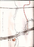 Children created map of their village
Children updated map of their village
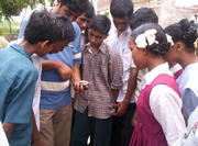
Children are learning use of GPS
contact for more details |

